July 5, Thursday, Ten Mile River Shelter to Stewart Hollow Brook Shelter, 15.7
Jason was also getting an early start, but I got out first. Along the Ten-Mile River, I could see rapids as I walked. Insects were already a problem, and gnats would torment all day, so I had to deet-up early.
Next was the climb up Schaghticoke Mountain, one thousand feet up, and when you thought you were on top and on the way down the trail goes right back up again. Hard climbing. Then a thousand feet down was not much fun either. Because of the elevation change I made much less than two miles/hour progress in the morning, which would be a taste of what we find in New Hampshire.
I take the road into Kent, around noon, planning four hours in town during heat of the day to thoroughly recharge cell batteries, then walk fast and late to next shelter, Stewart Hollow Brook seven miles away. One of the first shops in town is a combination outfitters and ice cream shop. They did not have replacement merino wool socks in my size :-(, but cone was fine. Actually two separate businesses in same building, and ice cream was from their own creamery.

Kent, CT
Further into town I paused at library to use facilities. They had wifi, so flushed the rest of my accumulated blog posts, then went to post office, but they were closed 2 to 2:30 for break. Fortunately laundry was nearby, so charged and washed and finished some journal entries. Then post office was open, so got my food box and repacked in lobby. Out back on way to trail, I am out of time to use library computer, so will have to do that next time, as I need to research and order some items.
One of my cell phone batteries does not appear to be in good health. After charging to 70% and unplugging, meter reads 30%. Jason had showed me an external rechargeable battery pack he picked up an an Apple Store, with name “morphie”. Perhaps I need to accept the extra weight and get one of these devices instead of a replacement cell battery.
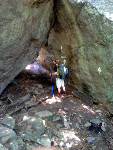
What with being inefficient and getting a final soda at the creamery, I do not leave town until 4:30PM. An initial 500 foot climb makes my freshly laundered day clothes not quite so fresh, alas. Meet a hiker at the top, Scrabble, who just recently resumed a thru-hike from 2008 to complete. We walked together a bit, then I need to fast-walk because I do not really want to arrive at shelter later than 8PM. After a feature named St Johns Ledges the trail takes a mildly terrifying descent on boulders to get to river level. We follow a river a long way, with a long distance between blazes that almost makes me turn around.
At 8PM I find the campsite, with several tents and hammocks. Follow the trail to the shelter, I am directed to a final campsite, where I discover Progress and Joiner. They had stayed at a hotel, and were forced to resupply from a convenience store, which is expensive. They said somebody was by with trail magic, promoting a new hostel, and they would offer pickup and delivery anywhere on Massachusetts trail. Sounds like a good option if I can stay at shelter when trail friends are also there.
Scrabble comes later to same campsite.
July 6, Friday, Stewart Hollow Brook Shelter to primitive camp near Limestone Spring Shelter, 22.3
One month on The Trail!
Started early and followed the river for a mile. Then the climbing started. Soon passed by Progress and Joiner, who invited me to join them for brunch in town tomorrow.
I knew by the trail profile that I would not have one big thousand foot climb like yesterday, but several 500 up-and-downs that could be even harder. No following ridgelines, and no real views to offer once we reached the heights.
In one narrow deep notch between rocks that hikers had to climb through, I way on a nearby ledge a huge bird, that may have been a vulture, just perched there, perhaps ready to feed off the broken carcasses of hikers who get into trouble in that notch.

Arrive at Pine Swamp Brook Shelter at noon, and write this entry:
Happy one monthiversary to me!
6/6/2012 HF to ME
6/6/1988 GA to HF
SagebrushPS: Thanks to all the long distance hikers answering my newbie questions in June, and not whapping me upside the head when I got obnoxious. You know who you are. Actually, most of you are north of me and cannot read this.
Hear this tremendous roar of engines. A race is underway on a track far below. Even though my batteries are low I need to listen to podcasts to keep going. Arrive at falls just after the generating plant, around 5:30PM, where many teens are swimming. I find a nice cache of trail magic: brownies and tea, fresh fruit, snacks. Not just nice, but essential boost to get up the mountain. A couple swimming down in the fall pools sees me, waves, and comes up. It is Ducky and Crazy Goose, trail angels who provided the magic. They were thru-hikers last year, live in Hartford CT, 1.5 hour drive, and come out some days to do trail magic.
They passed on a message from Joiner and Progress that they wouldn’t go the 0.7 mile side trail into Limestone Spring Shelter, but would camp out near the AT by the side trail. Good to know. Less hiking.

Ducky and Crazy Goose
Still, with talking to the angels, I do not head up from the falls until 6:30PM, and wonder if I will have to night-hike at the last.
Up the trail loose dogs come near. One is friendly, but the other, a golden retriever (!) barks aggressively and is not willing to let me pass. Finally the owner comes down the trail, a woman, fifty-ish, who gives the standard dog owner “The dog is friendly” salutation and expresses the standard dog owner amazement at why her precious is acting out.
On up the trail, not too punishing for a change.
Arrive at 9PM and find Progress and Joiner in their tent. I set up a tent nearby, wipe off, and fall asleep after a challenging day. I do not even fix dinner, but trail magic was apparently enough.
July 7, Saturday, primitive camp near Limestone Spring Shelter to The Hemlocks Shelter MA, 17.5
Left camp at 6AM, made Salisbury Connecticut by 8AM, cute little expensive quaint village with bistros and movie star residents. Progress, Joiner, and I have several choices but settle on the Country Bistro and eat inside but away from less smelly patrons and near the air conditioning. The breakfast burrito seems to be the value selection, which I tried.
Joiner was accepted to George Mason MBA program this week, with a direction in corporate or international corporate studies. Great news.
After the meal I go to charge, but the phone does not recognize a battery is inserted. Oh no, a battery died, and that was the good battery! I am in trouble.
Progress has news: Golden and Wildflower may be in Salisbury right now. They were texting. Seems like they had taken a couple of days off.
Steamer sees me through a coffee-shop window. He is staying across the street in a lady’s house for $40/night, waiting for days to get cooler. A “cold” front is expected to pass through today, with scattered showers. As a big guy he overheats easier than us small people. He has all kinds of shops within a three block distance. I should take the bunk next to his, because his room rate is a steal for such an up-scale tourist spot, but stubbornly I am determined to put in some miles.
Progress and Joiner resupply at the up-scale grocery, where protein bars are rather more expensive– hiker world problems. I charge a little more and journal, but realize my one remaining battery is crying for an overnight recharge. I do not realize it yet, but so is my body.
I leave Progress and Joiner and head up the Trail, planning on getting water at the cemetery out of town. Trouble is, faucet broken, if that piece of pipe used to be the faucet. Oh, well. Another four miles. I am so glad the waitress at lunch kept refilling our ice water. I see Milk Jug preparing to thumb into town. He holds his American flag he got for the Fourth while hitchhiking. Not a bad idea…
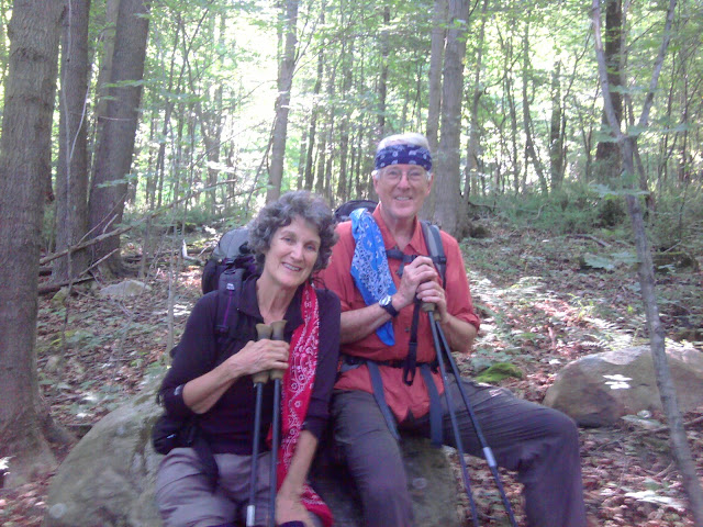
Very shortly I water at an unlisted stream, and start the thousand foot climb to Lions Head. I am joined by Progress and Joiner, and fall in behind them at their challenging pace that is still within my comfort and safety limits. We fall into easy conversation to take our minds off the rigors being imposed on our bodies. I know she started the AT several weeks before and then he joined he. Was this planned all along? No, they had section hiked for a week together, and he definitely decided long distance hiking was not for him, while she was even more certain she wanted to thru-hike. But after a few weeks on The Trail, she was lonely, so he quickly got ready and joined her. Wow!

Joiner and Progress
Also asked about her involvement with horses (knowing that would pass the time, since horse people have a lot to say about their passion.) She participates in eventing, which is scored rather than judged like, say, Western Pleasure. She dreams of owning her own riding stable someday, and maybe keeping ten horses for lessons, but will not board horses. She has researched and believes you cannot make money boarding, while letting yourself in for a continuous stream of complaints. She also sees in the near future the difficulty of justifying the expense of her activity where she lives in northern Virginia.
At Lions Head we meet Runner, a 60-ish thru-hiker, who started mid-march, though none of us had met him before. In discussion he learns I did chip design and describes being part of an in-house CAD group in the 90s, before shifting to another job at Martin. With pardons to Progress and Joiner, we geek out for a while as the four of us descend down to shelter. I do not get to talk geek much on The Trail, so enjoy thoroughly.
We get in early enough at The Hemlocks Shelter, 6:30PM, that I can find water, rinse off day clothes, and myself, which I hadn’t been able to do for a couple of days. Spacious shelter with bunks. A loft is used by Progress and Joiner. We are joined by Lorax (18, talks like surfer dude) and a couple of actual thru-hiker southbounders who seem lean and hungry, like they have been through an ordeal. Hmmm.
July 8, Sunday, The Hemlocks Shelter to hotel at Great Barrington, 16.4
I am noticing people are more likely to get out of shelters early compared to near Harpers Ferry, where even starting to move before 6AM might wake people. Now we want to be on the Trail while still cool. Runner and I head out early, me leading. Each of us have a son and daughter, though his are married and out in the work force, and we compare notes while climbing up and down. At Massachusetts Highway 41 we are about to go down the road for a grill place Joiner found in Awol, but first Runner spots trail magic: a cooler full of cans of cola, covered in ice. We each enjoy a can, and move on. A half-mile road walk and we see no sign of a grill. I decide to go on three more telephone poles, and we see something. Sure enough, it exists. Bad news though, does not open until 4PM on Sundays. I don’t think we will want to wait five hours. We pause for me to charge and we eat lunch snacks and get water under a shady pavilion with picnic tables for outdoor dining. As we are about to leave Progress and Joiner show, and we deliver the bad news.
Back to the trail crossing and we see a trail angel tending the cooler. She thru-hiked toe AT in one direction, here now-husband thru-hiked in the other direction, and they met on the John Muir Trail. They share trail angel duties.
On the Trail and a sharp ascent, with Runner in front. Soon he outdistances all of us, and we do not see him again! We get to Highway 23, and I decide to get off the Trail and bid them farewell. P&J hike long days and are not due to take off for more than a week. But will eventually stop and meet her dad. I will not likely see them for a long time, and thank them warmly for the good trail conversation.
I am headed four miles along a highway in the heat of the day to Great Barrington, which has motels and a K-Mart and Radio Shack. My goal is to find a place with wifi, charge up thoroughly, order equipment for the weeks ahead, improve the battery situation, and enjoy a real bed.
I am not comfortable with hitchhiking. However, after a couple of miles I resort to no-thumb hitching from advice I overheard from other hikers: hat off, big small, look them directly in the eye, walk backwards facing traffic. I am not good at the technique, but a teen soon stops and gives me a lift and shows me the “cheap” hotels in town. My phone is completely dead, so I cannot look at prices on “Companion”, so walk to a few and settle on Lantern House Motel, at $100/night, which injures my sense of cheapness. However when I ask about wifi and the manager admits reception is spotty in some rooms, and I explain I cannot go out to the good reception area because my phone battery is at zero, he takes me around to a couple of different rooms for me to plug in and try for best reception. Bemused, I do settle on this motel.
I do not shower because a soaking bath is better. Limp out to K-Mart and Radio Shack and they actually have stuff I can use. I send off a flurry of messages to “Base Support” and order items online. “Base Support” acted on my previous plea for help and went to Apple Store for an external battery pack and will send to Dalton MA food drop.
I work on the “dead” cell phone battery, and by plugging and unplugging the charger fifty times I convince the cell phone to recognize it as a real battery again.
Now for some deep recharge, both for the batteries and myself.
July 9, Monday, hotel at Great Barrington to Upper Goose Pond Cabin, 19.1
Free continental breakfast isn’t until 7AM, for forget an early hiker start. I scarf a huge pile of bagel sandwiches and assorted pastries. Up the road by 8AM; no kindly teens offer me a ride to the trailhead, but a good night’s sleep gets me to the trail by 9:30AM.
Getting to Mount Wilcox South Shelter for late lunch and water break, I find the water not good. Sigh. I go further and find an unlisted stream with better water.

Beaver sign
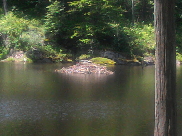
Beaver den
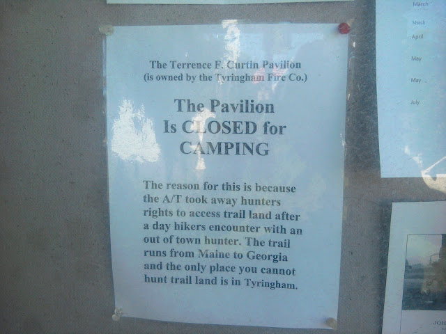
I need to stop at Tyringham post office for a package, but that presents a problem: The office closes in early afternoon until 4PM, which makes me late to the nearest shelter opportunity, Upper Goose Pond Cabin, a really nice stop recommended by hikers. By 4:30PM my food is arranged and letters mailed, and I go across the street to a bed and breakfast to inquire about rates. Unfortunately the proprietor is nowhere to be found. Hmmm, what to do? No camping at non-official campsites along the Trail in this state, no campsites until Upper Goose Pond, which I “might” reach at 8:30PM on my best day. Tyringham used to allow camping in a public pavilion, but this notice is posted in the post office community bulletin board:
The Terrence F Carrin Pavilion (is owned by the Tyringham Fire Co) The Pavilion is closed for camping, the reason for this is because the A/T took away hunters rights to access trail land after a day hikers encounter with an out of town hunter. The Trail runs from Maine to Georgia, and the only place you cannot hunt trail land is in Tyringham.

Tyringham MA
Great, now I am caught up in factually dubious politics. Climb on. Assisted by podcasts, yet the way is hard, and I flag, and my pace reduces. At 7:30PM I notice how dark the forest interior becomes. I can still navigate fine at 8PM. Finally the headlamp comes out. I’ve heard of hikers making great progress on night hikes. They must have bigger heavier headlamps and younger eyes. My pace slows to a crawl. Around 8:45 I encounter the Goose Cabin Tent Area, with no food bags in the bear box. Of course, everyone went to the much nicer cabin.

Upper Goose Pond Cabin
Now I make an error of judgement brought on by fatigue. I should stay at the tent site, on the wooden tent platform. Instead I press on to the cabin. Everyone is already asleep upstairs, and I slip in as quiet as a mouse and put my bedroll next to the hearth downstairs and close my eyes.
July 10, Tuesday, Upper Goose Pond Cabin to Kay Wood Shelter, 17.6
Some hikers slipped out of Upper Goose Pond Cabin early, around 6AM. I gather up my bedroll from the floor quickly and pack my gear. Twenty-two hikers and the caretaker stayed overnight. Several familiar faces, including some I did not seen in a long time: golden, Roadhouse and Chesty (from Kentucky), Pacemaker and Buckeroo, Wildflower (normally hikes with Golden), Meat (last seen in shelter with Mad Hat) Z, Runner, Lorax, Houdini.

Upper Goose Pond
Although my body feels fine after the previous long day, my brain is fuzzy. I do not think I was coherent when asking Golden about text Progress received in Salisbury CT, saying we were in town at the same time.
The caretaker makes pancakes and we are all invited to partake. Afterwards I volunteer for dish washing duty, and Golden joins, with Meat “supervising”. As we wash, they each tell tales of the food service industry. A lot of fun and laughter makes washing dishes a high point of the day.

Golden and Meat clean dishes at Upper Goose Pond
Plenty of up and down hiking, hemlock and pine alternating with deciduous, mixed with bogs, plenty of bugs. We start seeing roots in the Trail outnumber rocks. One root catches my toe as I am bringing the foot forward, hyper-extending and causing injury that slows me the rest of the morning.
I limp into October Mountain Shelter and say “hello” to Roadhouse, Chesty, and others I do not recognize. I get water to ice down my calf, then cook two dinners and eat each! My body is telling me to get more protein and calories, and fast! Has not hit me like this before. Roadhouse points out a new hostel, free, in Dalton that has a good rep, but not much is known regarding laundry, wifi, facilities, etc.
When I leave shelter and resume hiking at 2PM I realize I would not get into Dalton until 8PM, too late to shower and bed down in a hostel without disturbing someone. Do NOT want to repeat last night’s risk venture!
I need podcasts to keep me going. Fortunately batteries are good. Keep hiking until I run out of ‘casts and then hike some more. Several times run into Buckeroo and Pacemaker. Each are retired teachers, in late 60s, from Virginia, who have done several AT section hikes and are out again. Very friendly and easy to talk to.
Pacemaker and Buckeroo
Kay Wood Shelter appears finally at 7:30. Already arrived are Marissa and Michael, recent Cornell grads, out their second day of the trail, southbound. He did a biomechanics degree but hopes for masters to be mechanical engineering for more options. She majored in agricultural science (!) but plans to switch to landscape architecture. They are loaded down with gear, but older model SteriPEN failed, so water is a problem, though they have tabs as backup. Michael peppers me with questions enthusiastically. Marissa is a runner, which must help in the beginning days of a backpacking trip.
Buckeroo and Pacemaker come and set up their tent. Michael and Marissa will take the loft of the shelter. B&P arrive too late in the evening to safely make the steep climb down to water in the lessening light. Marissa offers to go, but B&P have enough for tonight. I offer SteriPEN for anyone tomorrow as long as my charge lasts, since I only have a couple of miles to town in the morning.
As we settle into the shelter, Marissa asks me if the presence of mice is normal. Both are wearing headlights, and the little eyes must reflect. Michael comes up to the loft, also sees an excess of rodents, and they vote to put up tent.
Now that they mention it, the mice are particularly noisy tonight. I remember the horrible feeling of having a mouse run across my face at night, on an earlier trip, and put on my head net… and sleep, and leave the mice to their games.
July 11, Wednesday, Kay Wood Shelter to Birdcage Hostel in Dalton, 3.0
The mousies may have scurried and scampered through the night, but I slept. Since I have a “nero” (near-zero mileage, as compared to “zero”) planned, I wait until 7AM to rouse the young sobos (southbounders) to help them with water. Marissa climbs down and quickly fills containers, and I irradiate the water liter by liter. I am using one of their wide-mouth containers with the steriPEN, but cannot help thinking about the device falling from my grasp while stirring, and becoming totally immersed. Maybe my narrower bottle helps prevent this failure mode, hmmm? After the water processing, I begin the short downhill morning hike.
The Birdcage Hostel does not list an address, just a phone number. Rumor is the guy running the hostel can be found at a Shell station. I notice the person offering water at a faucet along the Trail in town also allows camping in the backyard. I could have stayed here and arrived late and not worried about disturbing hikers. At the faucet place, I see Z talking to some other hikers (and bikers). Apparently the guy of the house was off helping some hiker slack-pack!

Thomas Levardi house for faucet and tenting

Dalton MA
Watered, I proceed further into town. An ice cream place does not open until noon. The library also opens late. I go to the post office, and find Roadhouse and Chesty. They stayed at the Birdcage last night, and Roadhouse gives precise directions. Problem solved! I hear the owner will not be back to the house until 11AM, but I carry my food box to the hostel, see who is around (only one sobo: Old Bay) and do a thorough amount of food repacking while waiting. Roadhouse and Chesty will stick around for a poison ivy foot doctor appointment, and they tell me about the hostel. The host Rob comes in, takes my pic– what a great guy, but crazy to open his entire house to hikers.

Birdcage Hostel

Rob Bird
I go to the library to find cell signal and converse with “Base Support”, write a post or two, then a blog comment mentions ice cream, and I have to find the shop I passed before. Hershey’s brand ice cream again, and I eat and catch up on posts. Then go to the general store and grab a sub and catch up on journals.
Returning to Birdcage, close to the general store, I learn that Rob does laundry in batches, mixing people’s stuff to get a full load, so I give out my dirtiest. Later I discover Rob actually has a big stack of “town clothes” for us to wear, so I could put everything in the wash. Also hear that Rob will take any who want to come to an all-you-can-eat place at 7PM. AYCE is a magic word to hikers. Several familiar faces trickle in all afternoon: Possum & Almost Awesome, Houdini, Steamer, Sticks and Metric, and more. Out in the back yard, Roadhouse and Possum start telling tales. I know Possum tells funny stories, but did not realize Roadhouse had similar talents.
The big white van pulls up at 7PM and is filled by Steamer, Houdini, Almost Awesome & Possum, Sticks & Metric, Roadhouse, Chesty, me, and sobo Old Bay, who is along for errands since he did AYCE yesterday. We go to Country Buffet. Roadhouse wishes they had biscuits for biscuits-and-gravy (essential southern food) but it is not to be. We do not lack for other choices, though, and you never saw skinny people go through so many plates. And Possum and Roadhouse really get warmed up and keep us all laughing.
Back at the Birdcage I am getting lots of comments on how swollen my feet have become. Maybe going in sandals and stopping analgesics when I’m not hiking make it worse. I elevate feet overnight on my cot on the screened porch. Big feet or not, tomorrow I will be energized and ready for big miles.
July 12, Thursday, Dalton to Wilbur Clearing Shelter, 20.5
Since I was sleeping on a cot on the screened porch of the Birdcage Hostel, it was easy to make a quiet exit by 6AM. I needed wifi for some final e-mails, so made my way to library,. Fortunately wifi remains on after-hours. Made way back to AT at 7AM.
The morning hike did not seem too difficult after a “nero”. Shortly after 11AM I arrive at Chesire, a cute little town with really nice widely-used bike path. At the entrance to town is a tiny ice cream and sandwich shop, which is closed. :-( As I am filling my water bottles, someone comes to open the store :-). I get a sandwich and cone, and wave over Almost Awesome and Possum, who just arrived. I eat at the nearby shady picnic table, when Possum comes over with a banana split served in a pie plate with six scoops– enormous. They go on to the general store for resupply, while I hike on.
Mark Noepel Shelter is only a fourteen mile day, so I commit to climbing Mount Greylock and going on the Wilbur Clearing Shelter for a long day.

Gore Pond
Podcast help. The Ape Team soon pass, but no one else yet from the hostel, which is odd.
Finally I get to the top of Mount Greylock. Joiner and Progress had written in a blog comment that Bascom Lodge up on the peak had ice cream. I find the Ape Team preparing to go down, and they did not find much to snack on. I go in, find only two tiny containers of homemade ice cream in the freezer, plus some popsicle treats and sodas. I get a few items and down them quickly, the start down.

War memorial at Mt Greylock

View from Mt Greylock
A while later I come to a sign for another minor summit. I take some photos and prepare to move on. Oops, a problem! Coming off the viewpoint I discover the northbound and southbound trail are right next to each other and look identical, with no signs. I cannot tell which way I came in!
Well, I choose a trail and follow it for a while. I convince myself I am seeing new trail, when I meet Sticks and Metric. I sheepishly explain what happened, then follow them down to the shelter.
I choose to sleep inside the shelter, since it is so late. Chesty and Roadhouse arrive late, and Chesty sleeps in shelter. Too late to hose off, or rinse out clothes. Quick wet wipe clean up, then ready for nighty-night.
I turn my wrong way mishap into a funny story for my shelter-mates. Sometimes you have to laugh at yourself, before someone else does first.
Related Posts: