Waterton?

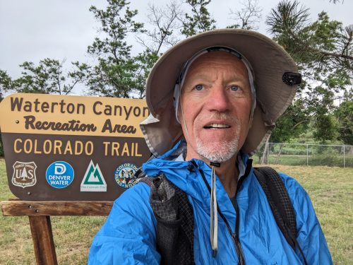
  • CT day 1, June 30, Friday
  • Start: Abq to Denver, then 3 light rails and rideshare to Waterton Canyon Trailhead
  • End: Section 2 (S2) mile 0.5
  • Miles walked: 17.3

The route from Denver Airport went quickly, thanks to the city’s has a well-developed light-rail system The trains could only get me to within 10 miles of the trailhead so I used a ride-share app. Due to some glitch, we actually ended up at a Lockheed facility. The driver, whose English was not 100%, misinterpreted the reaction at the guard house and thought it was okay to proceed to the main building, And I was having trouble conveying my panicking concerns about the situation and that we are definitely at the wrong location. We got things straightened out and went to the correct location, but not before huge angry men with guns appeared and had a polite discussion with us. I did not take photos.

Rain and lightning started just as I began the trail, but was brief.

Continue reading “Waterton?”

Next Trip: The Colorado Trail

My ‘long hike’ for 2023 is the Colorado Trail (CT), approximately 500 miles, from just outside Denver to Durango, near the southern state border with New Mexico.

The average elevation is 10.3k, and the highest elevation is 13.3k. I hiked a good part of the CT way back in 2014, where the CDT in Colorado shares a good portion of the route.

Join me on my journey, by visiting this blog or subscribing.

Trails and Graph Theory 7: Apply Tools

Let us take the tools we developed in the last post and apply to the much larger graph of the Gila National Forest, and see what needs debugging. We follow nearly the same steps as the previous post, so refer to that article for an explanation of why we are taking particular steps in a certain order.

One thing discovered after experimentation is that OSMnx embeds a good deal of geometry information on the attributes of graph edges and graph nodes, so my contract_twos function would need a good deal of modification to correctly join the geometries of two edges to a single edge. Instead, we will use a shortcut. OSMnx has a simplify_graph function, which eliminates all nodes of degree 2, but it can only be used once. (I pray that the maintainers of the OSMnx library might remove that restriction in later releases. ) Before, I used that function just after reading in the OpenStreetMap data, but now we will wait. The trade-off is that we start out with a graph with a huge number of nodes for our initial graphs. Our draw function that can handle OSMnx graphs has an option to show the nodes.

OSMnx version:  1.4.0
NetworkX version:  3.1
report(G)
79985  nodes  
79983  edges  
total length 1546.96 miles  
number of zero-degree nodes  : 11
number of odd intersections  : 900
number of even intersections  : 79085
number of 2-way intersections  : 79027
number of trailhead/terminus  : 489
draw(G)

If we turn on display_nodes, we see a jungle of them. The extra nodes slow down calculations, but not too much to bear. (Perhaps I need to display nodes in a higher contrast color than ‘pink’.

Continue reading “Trails and Graph Theory 7: Apply Tools”