“No battle plan ever survives contact with the enemy.”
Field Marshall Helmuth Carl Bernard von Moltke
No trip itinerary survives more than a few weeks on The Trail, either, but make one anyway.
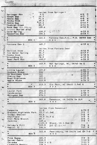
Behold one page of my 1988 thru-hike trip plan.
The complete itinerary is included below in searchable text format. Soon my 1988 trail journal will be posted, so you can see how closely I followed the plan.
| (miles from Springer) | ||
| Springer Mountain | 0.0 | 6/6 M |
| Gooch Gap | 16.7 | 6/7 T |
| Neaes Gap | 31.6 | 6/8 W |
| Rocky Knob | 49.4 | 6/9 R |
| Addis Gap | 63.4 | 6/10 F |
| Muskrat Creek | 80.7 | 6/11 S |
| Rock Gap | 109.6 | 6/12 S |
| (Buried drop) | ||
| Cold Spring | 125.7 | 6/13 M |
| Sassafras Gap | 144.1 | 6/14 T |
| BOX 1 | 164.4 | Fontana Dam, NC PO 28733 2mW |
| Fontana Dam S | 165.7 | 6/15 W |
| (miles from Fontana Dam) | ||
| Derrick Knob | 20.4 | 6/16 R |
| Ice Water Spring | 40.7 | 6/17 F |
| Cosby Knob | 60.7 | 6/18 S |
| Groundhog Cr | 78.3 | 6/19 S |
| Deer Park Mtn | 100.7 | 6/20 M |
| Box 2 | 103.9 | Hot Springs, NC 28743 0m G |
| Little Laurel | 123.2 | 6/21 T |
| Hogback Ridge | 144 | 6/22 W |
| No Business Knob | 162 | 6/23 R |
| Cherry Gap | 185 | 6/24 F |
| Roan Highlands | 203.3 | 6/25 S |
| Apple House | 212.8 | 6/26 S |
| Box 3 | 213.3 | Elk Park, NC 28622 2.5mE G |
| Laurel Fork | 234.4 | 6/27 M |
| Vandeventer | 251.2 | 6/28 T |
| Abingdon Gap | 274.1 | 6/29 W |
| Box 4 | 283.9 | Damascus, VA 24236 0m GLM |
| (miles from Damascus) | ||
| campsite | 11.8 | 6/30 R |
| Grayson Highlands Park | 33.7 c1.2mE | 7/1 F |
| Trimpi Shelter | 53.6 | 7/2 S |
| Chatfield | 70.9 74.9 G | 7/3 S |
| Knot Mole Branch | 89.7 | 7/4 M |
| Jenkins | 109.6 | 7/5 T |
| (121.2 Bland, VA 1.8mW GM) | ||
| Helvey’s Mill | 123.5 | 7/6 W |
| Wapiti II | 146.6 | 7/7 R |
| Box 5 | 162.8 | Pearisburg, VA 21334 1mE GM 7/8 F |
| Pine Swamp | 181.5 | 7/9 S |
| Sarver Cabin | 205.9 | 7/10 S |
| Catawba | 226.3 c G | 7/11 M |
| Lamberts Meadow | 239.0 | 7/12 T |
| Box 6 | 248.8 | Cloverdale, VA 24077 |
| Wilson Creek | 261.4 | 7/13 W |
| Cove Mtn | 274.3 | 7/14 R |
| Thunder Hill | 290.2 | 7/15 F |
| Johns Hollow | 307.5 | 7/16 S |
| Brown Mtn Creek | 325 | 7/17 S |
| The Priest | 347 | 7/18 M |
| Box 7 | 351.7 | Tyro, VA 22976 1.2mE G |
| Maupin Field | 360 | 7/19 T |
| Waynesboro motel | 377.7 | 7/20 W |
| (miles from Rockfish Gap) | ||
| Blackrock Hut | 20.1 | 7/21 R |
| Hightop Hut | 41.5 | 7/22 F |
| (Lewis Mtn Campground | 53.1 GLC .1mW) | |
| Rock Springs Hut | 65.4 | 7/23 S |
| Pass Mtn Hut | 80.4 | 7/24 S |
| Tom Floyd Wayside | 103.5 | 7/25 M |
| (miles from Front Royal, VA) | ||
| Box 8 | 6.8 | Linden, VA 22642 0m |
| Manassas Gap | 10.6 | 7/26 T |
| Rod Hollow | 24.2 | 7/27 W |
| Keys Gap | 47.8 | 7/28 R |
| (Harpers Ferry, WV, ATC HQ) | ||
| Crampton Gap | 64.6 | 7/29 F |
| Box 9 | 64.2 | Burkittsville, MD 21718 1.2mE G |
| Hemlock Hill | 7/30 S | |
| (PA-MD line | 94.7) | |
| (miles from PA-MD line) | ||
| Tumbling Run | 7.8 | 7/31 S |
| Birch Run | 27.0 | 8/1 M |
| Moyers Campground | 47.6 | 8/2 T |
| Darlington | 70.3 | 8/3 W |
| Box 10 | 82.1 | Duncannon, PA 17020 0m GLM |
| Peters Mtn | 92.5 | 8/4 R |
| Rausch Gap | 109.8 | 8/5 F |
| Hertzlein Campsite | 129.9 | 8/6 S |
| Port Clinton | 148.4 | 8/7 S |
| Box 11 | 148.4 | Port Clinton, PA 19549 |
| Allentown Hiking Club | 172.8 | 8/8 M |
| George Outerbridge | 191.4 | 8/9 T |
| Leroy Smith | 208.1 | 8/10 W |
| Box 12 | 227.9 | Delaware Water Gap, PA 18327 0m RGLM |
| (miles from DW Gap) | ||
| *** | *** motel | 8/11 R |
| Brink Rd | 24.5 | 8/12 F |
| High Point | 44.1 | 8/13 S |
| campsite | 67.6 | 8/14 S |
| Box 13 (motel) | 89.5 | 8/15 M |
| William Brien Mem. | 101.2 | 8/16 T |
| Dennytown Rd campsite | 124.6 | 8/17 W |
| Morgan Stewart | 144.1 | 8/18 R |
| Webstuck | 160.5 | 8/19 F |
| (CT-NY line) | 161.4) | |
| (miles from CT-NY line) | ||
| Mt Algo Lean-to | 11.0 | 8/20 S |
| Box 14 | 11.3 | Kent, CT 06757 .5mE GLM |
| Dark Entry | 24.3 | 8/21 S |
| Pine Knoll Lean-to | 41.8 | 8/22 M |
| Bond Lean-to | 58.4 | 8/23 T |
| Glen Brook | 67 | 8/24 W |
| Mt Wilcox Lean-to | 86.1 | 8/25 R |
| Box 15 | 93.0 | Tyringham, MA 01264 0.0m L |
| October Mtn Lean-to | 108.1 | 8/26 F |
| Bassett Brook campsites | 132.1 | 8/27 S |
| (VT-MA state line) | 145.9 | |
| (miles from VT-MA state line) | ||
| Congdon Camp | 10.0 | 8/28 S |
| Story Spring | 32.9 | 8/29 M |
| Mad Tom | 52.4 | 8/30 T |
| Greenwall | 73.3 | 8/31 W |
| Box 16 | 75.2 | Wallingford, VT 05773 3.5mW GLM |
| Governor Clement | 87.1 | 9/1 R |
| Stony Brook | 104.7 | 9/2 F |
| Cloudland | 122.5 | 9/3 S |
| Box 17 | 137.5 | Hanover, MA 03755 0.0m GLM |
| Velvet Rocks | 139 | 9/4 S |
| Smarts Mtn | 161.7 | 9/5 M |
| Jeffers Brook | 184 | 9/6 T |
| Kinsman Pond | 202.7 | 9/7 W |
| Mt Guyot | 223 | 9/8 R |
| Box 18 (motel) | 246.6 | Mt Washington, NM 03589 9/9 F |
| Osgood tentsite | 255.2 | 9/10 S |
| Rattle River | 277.9 | 9/11 S |
| (Gorham, NH) | 279.5 G 1mE | 9/12 M |
| (ME-NH line | 0.0) | |
| (miles from ME-NH line) | ||
| Carlo Col | 0.5 | 9/13 T |
| Frye Notch | 19.9 | 9/14 W |
| Elephant Mtn | 39.9 | 9/15 R |
| Piazza Rock Lean-to | 62.2 | 9/16 F |
| Spaulding Mtn Lean-to | 78.5 | 9/17 S |
| Box 19 | 91.1 | Stratton, ME 04982 5mW GLM |
| Horns Pond Lean-to | 96.4 | 9/18 S |
| Jerome Brook Lean-to | 109.9 | 9/19 M |
| Pleasant Pond Lean-to | 133.4 | 9/20 T |
| Breakneck Ridge Lean-to | 153.9 | 9/21 W |
| Box 20 | 162.9 | |
| Old Stage Road Lean-to | 167.1 | 9/22 R |
| Cloud Pond Lean-to | 185.5 | 9/23 F |
| Logan Brook Lean-to | 208.8 | 9/24 S |
| Potaywadjo Sp Lean-to | 231.5 | 9/25 S |
| (Abol Bridge | 264.5 G 0m) | |
| Daicey Pond | 271.8 | 9/26 M |
| Baxter Peak | 279.0 | 9/27 T |
For my 2012 long section hike to attempt Trail Completion, I am using a spreadsheet with some useful features for revisions. I’ll cover that in a later post.
Notes:
- Trip plan was composed on a text editor running on a home-brew PC compatible with 8088 CPU, printed on an Epson MX80 dot matrix printer, and then reduced to half-size on a copier. Editor was see.exe (bundled with the Desmet C compiler) which I still sometimes use today.
- Trail miles are given from state borders and other landmarks as noted because the Appalachian Trail Data Book 1987 presented miles that way, not cumulative miles from Springer.
- When depending on mail drops, as I was, be certain to add day-of-week to your trip plan. Arriving at a post office on Sunday may result in disappointment. Now with some post offices having reduced hours on Saturday this is even more of a factor. On the other hand, you will diverge from your original schedule eventually, so be aware.
- Although I didn’t get as far as New Hampshire, I now realize that I over-estimated how far I could walk each day on that section of the trail. Pay attention to large daily elevation changes.


