June 30, Saturday, Wildcat Shelter to William Brien Memorial Shelter, 19.6
Left Wildcat Shelter around 6:30AM and walked with Miles, who likes to start early. I had to make a pit stop and end up walking with Progress and Joiner for the morning. More technical climbing over huge rock outcroppings, with lots of trail ups and downs, with no ridgelines to speak of. Would hate to be attempting in rain or post-rain with wet rocks! We met a couple of thru-hikers, Sunshine and Rocky, who said their hiking bubble was already in the White Mountains. Progress started in April, joined later by Joiner. Golden, Peppaboy, and that crowd started mid-March by comparison. We talked about meeting again at William Brien Memorial Shelter after visiting Lake Tiorati for cooling, swimming, water, vending machine, and rumors of ice cream sandwiches.

Rocks
My left knee is hurting quite a bit on downhill. The cut is staying closed, but I must have bashed something inside the joint. The pain is very much in location and degree like my left-knee-troubles on southern AT trip. No problems with that knee before the bash.
It is HOT, but not quite as bad as previous day. I double amount of water consumed and carried, and take advantage of occasional trail magic where an angel leaves water on this dry section of trail.
In early afternoon I am with Progress and Joiner when we meet the Lemon Squeezer, a huge rock outcropping with a narrow passage underneath, in places easier if you take off your pack to scramble through.
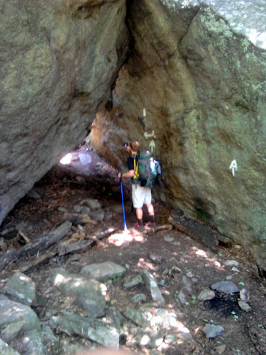
Joiner at Lemon Squeezer

Squeeeeeeeeze
Finally get to Fingerboard Shelter, no water, around 3:30PM, and I am pretty dry by then. We climb down to the road for Tiorati Lake, eventually joined by Miles, then walk along the road searching for “official” swimming area with restrooms,, cold showers, vending machines. Rumors of ice cream, so I hoped for concession stand. Finally got to destination and I drink two liters of water and two 12-ounce sodas before going down to “beach” to dip toes. With cut knee no lake swimming for me, but water feels good on the toesies. No concession stand but ice cream vending machine. Everyone in my party is treated to an ice cream from the machine. We meet Sunshine and Rocky as we are leaving.
We try taking a road shortcut but cannot find necessary blue-blaze trail We have to back-track a mile and take another road we know crosses the AT. By this time I am lagging well behind. My knee and feet claim it has been a long day. We find sweet white blazes and climb up to William Brien Memorial Shelter, a stone structure with massive thick walls. Right next to it is the big cliff we need to climb in the morning. All in our party tent because of heat. Rocky and Sunshine come by but move on. A group of young reprobates are camping nearby, and Miles yogis some beer in exchange for flammable liquid. The group is actually pretty quiet at night. I am tired, but really enjoyed the easy conversation among friends all during the day.

William Brien Memorial Shelter
July 1, Sunday, William Brien Memorial Shelter to primitive camp one mile past Bear Mountain Bridge, 11.1
Out of William Brien Memorial Shelter campsites by 6:30AM with Progress, Joiner, and Miles. Miles and I climb to the summit of Black Mountain, the first of three mountains on our morning schedule. Miles points out traces of the New York skyline; one glass building is catching the sun just right, barely visible over a rise and through the haze.

A glint of the NYC skyline seen from Mombasha High Point
When I descend down to the road (Palisades Interstate Parkway) I see a sign: “N Y City 34 (Miles)”. At the next brook I take water instead of waiting for a spring as in other states. In the morning we meet Sunshine and Rocky and walk together most of the way to Bear Mountain summit, with conversation ranging from cycling, half-marathons, hiking equipment. The pair had camped on top of Black Mountain to see NYC skyline at night. Since they are using hammocks and few trees are at the summit, this presented a challenge.

We encounter a large number of fitted steps leading to the summit, and marvel at the effort involved.

Fitted rock steps up Bear Mountain
On up West Mountain and down, then up to the summit of Bear Mountain, where we find vending machines but NO WATER… unless you want to pay three bucks for a small bottle of Dasani. Many cyclists are at the summit, exercising the vending machines and also searching for water. At the summit is a tower commemorating the history of the park, which we explore.

Perkins Memorial Tower at summit of Bear Mountain
Descending down to Bear Mountain Park wee meet more fitted steps, a wide groomed trail, many day hikers. I’m not making this up: I can small charcoal lighter fluid wafting from the picnickers below.
Finally we get down to the part. First order of business is water, so Miles, Rocky, Sunshine and I trek over to distant restrooms and partake. Slightly brownish, but drinkable. I soak hat, bandana, and shirt to ward off heat. Miles is taking a bus from Bear Mountain Lodge to visit parents in Long Island, so I bid him a warm farewell. Sunshine and Rocky are working on some issues– I hope to see them up the Trail. At the zoo I meet Progress and Joiner lunching in the cool shade of the trees. I only go as far as Hemlock Springs Campsite and backtrack a couple of miles in the morning for post office drop. They are going on to Graymoor Spiritual Life Center a few miles further. I hope to see them up The Trail again in a few days.

Miles departs at Bear Mountain State Park

Bear Mountain Lodge

Path along Hessian Lake, Bear Mountain State Park

Bear den, altitude 120 feet, lowest point on the AT
I walk into Fort Montgomery in heat of mid-day and get a few refreshments. ATM is out of order. Next two ATMs are inside businesses closed for Sunday. Finally I locate a Mobile Mart and get cash– just in case. Back to part and find an AC plug to charge while I journal. In walks the Scout troop I’ve met several times, celebrating the end of their Hundred Miler. Finally, just before the gates close at 4:30, I cross the Bear Mountain Bridge and head up to campsite and prep for tomorrow.

Bear Mountain Bridge
July 2, Monday, primitive camp one mile beyond Bear Mountain Bridge to primitive camp past Dennytown Road, 13.5
I was camping at a primitive site with water a mile up The Trail after the turn-off to Fort Montgomery. I headed down around 6:30 with only pack and foodbag and mesh bags. I tanked up on a half liter of water, saving two liters of water for later. I left the tent up like it was occupied.

Hudson River viewed from Bear Mountain Bridge
The post office opens at 8AM, so I arrive at 7:30 and plug phone into hidden outlet I had previously located. Got package as soon as office opens and proceed to repack some items.
The term for driving around looking for an open wifi connection is war-driving. I was “war-hiking”, and managed to upload some blog posts written the previous night. Connection was slow, but I did manage to post some content. On way back I need a restroom real bad, so asked a ranger in Bear Mountain State Park for permission even though back entrance not officially open until 10:30AM. By the time I get back to camp and packed up, it was already 11:30, and the best hours for hiking were gone. Hard to get into a good long hike rhythm. Finally started clicking around 2PM. Then came across a trail-adjacent deli mart, so I got a cold soda and looked in vain for bandages. For some reason both feet were developing blisters in unusual places that had not acted up before. Used molefoam as best I could. A group of thru-hikers were hanging out at a picnic table at the deli. Flash, who recommend several good places to eat previously at Delaware Water Gap, just as he was leaving hostel as I entered. Also present were hikers new to me: Coffee-to-Go, Foster, and Einstein. I asked if they had seen Sunshine and Rocky, and they said the pair had spent from 9 to 12 at the picnic table. I continued on after apparently breaking a tooth on a tortilla. Strange, right?
I hike on, and rhythm gets better or trail gets easier. When Flash catches up I ask him where he is from, since accent sounds like some of my relatives. He is from Winchester, Kentucky. The three others hikers catch up and pass me, but then take a break and I keep moving. This pass and catch up happens several times in the afternoon.
I was hoping to hike on to Clarence Fahnestock State Park and arrive late, but the group points out that one mile off the trail is two extra miles hiked. They mention camping areas should be nearby when trail crosses Dennytown Road. When I reach that spot around 6:30PM, I know I cannot hike much further. I am beat.
Almost Awesome and Possum (The Ape Team) show up and pepper me with questions about ultralight gear. They are a married couple; she is always bubbly and lively; he is quieter but tells great stories. They move on down to camp a few miles in.
Exhausted, I follow Coffee and crowd as they find a nearby campsite and ask to camp with them. Coffee-to-Go has a ZPacks tent like mine, but next larger size with an extended beak. Foster plays a mean blues harmonica and tells tales of following a band and encounters with “hippy chicks”. He also bursts out singing a country tune I’ve never heard before. he says he bought a pack of Indians (cigarettes) at last deli and already finished it: two cigs/mile?

Coffee-to-Go has Zpacks tent-tarp with extended beak option
Coffee is quite careful to make me feel welcome, part of the group. Flash is traveling with them, but seems an odd fit.
Somehow they found a campsite with no rocks or roots. When Coffee and I look for rocks as a weight to throw a bear line, we have trouble finding one! My bed is unusually soft as a result, and I have a good sleep.
July 3, Tuesday, primitive camp past Dennytown Road to Morgan Stewart Shelter, 19.7
I head out around 6:30AM, and find Rocky and Sunshine up The Trail about two hundred feet way camping. They give a sunny wave as I pass by.

An AT blaze being born
Go by Clarence Fahnestock State Park, looking at the lake and thinking of the beach. Maybe they have a place to charge, but it is early, the concession stand not open, and early is the best time to hike. Maybe I can charge at the deli later, if they are nice.

Canopus Lake,Clare
Hike. Hike some more.
Stop for short lunch break and water at RPH (Ralph’s Peak Hikers) Cabin , which is fully enclosed with chairs and niceties. Used the hand pump but SteriPEN water just in case. A thru-hiker arrives, Tamir, with his sister section-hiking with him.
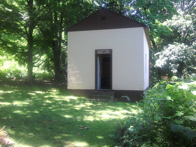
RPH Cabin
Around 2PM I reach Highway 52 and hike down to deli. Almost Awesome and Possum are at the picnic table, and tell me deli people are really nice, and the pizza place next door less so. I support the local economy with a dirty rice dish and snacks, and the clerk tells me I can charge at the outlet outside next to a faucet. Now I’m staying a while!
The Ape Team are from Knoxville Tennessee, and she went to University of Tennessee. Delightful conversation, rich in stories. I am energized just being i their presence. But not energized enough to move yet. They go up; Tamir and sister come down.
Eventually, around 4PM, I head up to Morgan Stewart Shelter. Chance of rain. So Ape Team and Milk-Jug are in shelter, and I join them.
Possum launches into story about Noodleheads in Shenandoahs, finding a luggage cart along the Trail, and Rigatoni is determined to use it. I was laughing so hard thought I would strain something.
Good honest twenty mile walk. How about tomorrow?
July 4, Wednesday, Morgan Stewart Shelter to Ten Mile River Shelter CT, 20.6
Left Morgan Stewart Shelter around 6:30AM, soon passed by the Ape Team (Almost Awesome and Possum) and soon by everyone except Tamir and his sister. Soon I meet Rocky, Sunshine, Flash, and another couple. There were slack-packing. They went to the Fourth of July Party advertised by flyers around the trail. They said the couple hosting the party were really nice, helping them to slack-pack today, and were probably just down at the road if I wanted to join the party. I said I’d just go ahead and hike on, grumbling a little to myself since I avoided any of the parties just so I could put in some miles.
The trail is relatively flat and non-technical, so I do put in some miles. Around noon or 1PM I get to the Appalachian Train Station, a tiny platform with no charging opportunity. I look at the nearby nursery that has a good reputation with hikers and might let me charge. But it is Fourth of July, so probably closed.
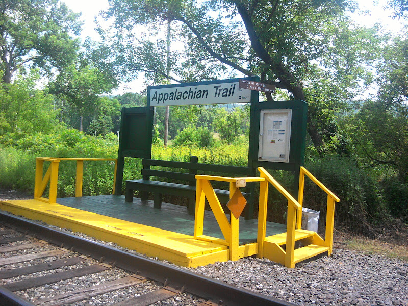
Lonely train station
As I am crossing the road to head up The Trail, somebody up the road waves me over with trekking poles as signals. It is Possum with Almost Awesome! They are standing next to a pizza truck and introduce me to Anthony, who actually has a wood-fired oven on his truck that gets up to 900 degrees F. I ask how many slices they ordered– Possum got two. Awesome started with one and then had to order another. So I get two with hot Italian sausage. Their ride arrives– this section of trail is kicking Possum’s posterior. I take one last photo and bid farewell, and concentrate on my ‘za.

Possum and Almost Awesome at Anthony’s pizza truck
Who drives up? Guess? “Sagebrush!”, says G-Bird. She, Peppaboy, Willie from Vermont, and another guy just got picked up a few days ahead on the trail, and staying with guy’s family tonight. “It’s an Independence Day Miracle!” I exclaim. They stopped here for pizza, so I tell them what I learned, and then fondest farewells, since one of us needs to hike for a living.

G-Bird, Peppaboy, and Willie from Vermont, July 4 surprise
Energized from two chance meetings with two fine groups of trail-buddies, I hike easily in the heat of the day with sweat pouring off me. At a road crossing I meet Jason, a thru-hiker who started in early March. Also at the road is trail magic: ice water (with ice still floating in container), cookies, and a first aid kit. And Jason, who is just back from visiting New York City, offers me a Snickers.

Trail magic, with cookies
We meet again at Wiley Shelter when I stop for water, and decide we are both headed to Ten Mile River Shelter. I get to the shelter at 6PM, plenty of time to get clothes rinsed and clean myself up before dinner.
Jason comes shortly afterwards. Earlier he had said he wast not sure of the cultural reference of why he was named Jason, and though it might be connected with the horror movie franchise. I ask if perhaps the reference is to Jason Alexander, actor on Seinfeld. They have the same general look and even similar speech mannerisms. he graciously agrees that might be a better explanation.
We talk most of the evening, often about trail people we know in common, but also about himself. He works for Liquor Control Board in Pittsburgh, and saved vacation days to do this adventure. He moved to Key West in his youth for a few weeks, until a best friend stabbed him. His father also thru-hiked the trail many years ago.
We fall asleep to the sound of fireworks and thunder. Happy 4th everyone.
Related Posts: